Nr. 13642331
Verkocht
Eindbod
€ 638
342 weken geleden
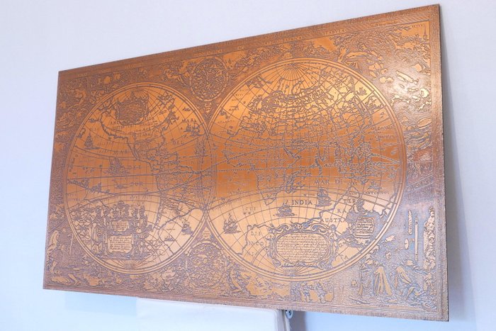
Large world map in copper according to Hendrik Hondius

Large map of the world in copper. At the top there is a text in Latin “Nova - Totius - Terrarum - Arbis - Geographica”. AC Hydrographica Tabula.
The original was created by Hendrik Hondius in 1641.
On the left half, we can see North & South America, New Guinea.
Many figures in the foreground with a text about Christopher Columbus.
On the right we can see Europe, Asia, Africa, China, India...
The sea is decorated with ships from the 17th century and some mythological representations.
Many representations on the sides, decorated with water elements, fire, earth and air, and the four seasons.
The plate is glued on a wooden support
In good condition.
Dimensions: 119cm x 69 cm.
Neat shipping with tracking and insurance included (Colissimo or Mondial relay depending on the country)
Nr. 13642331
Verkocht
Large world map in copper according to Hendrik Hondius
Large map of the world in copper. At the top there is a text in Latin “Nova - Totius - Terrarum - Arbis - Geographica”. AC Hydrographica Tabula.
The original was created by Hendrik Hondius in 1641.
On the left half, we can see North & South America, New Guinea.
Many figures in the foreground with a text about Christopher Columbus.
On the right we can see Europe, Asia, Africa, China, India...
The sea is decorated with ships from the 17th century and some mythological representations.
Many representations on the sides, decorated with water elements, fire, earth and air, and the four seasons.
The plate is glued on a wooden support
In good condition.
Dimensions: 119cm x 69 cm.
Neat shipping with tracking and insurance included (Colissimo or Mondial relay depending on the country)
Stel een zoekopdracht in
Stel een zoekopdracht in om een melding te ontvangen wanneer er nieuwe resultaten zijn.
Dit object was te vinden in
Zo koop je op Catawiki
1. Ontdek iets bijzonders
2. Plaats het hoogste bod
3. Veilig betalen